Track ships online by name. Tracking ships in real time. This video will show you how to use Marine Traffic
Would you like to know where this or that sea vessel is now, which ships are located near you, and which dock in Buenos Aires, Sumatra or Singapore? The MarineTraffic.com web service gives you a unique opportunity to get a lot of useful information on the location and movement of the vessel you need on the map, its route, speed, cargo, weather in a given region, and so on. In this article I will tell you about the real-time traffic map of the vessels on the Marina Traffic website, and also explain in detail how to use the capabilities of this service.
AIS navigation
As you know, AIS (Automated Identification System) has been involved in navigation since the beginning of the 90s, the main purpose of which is to increase the monitoring and safety of maritime transport. Its capabilities make it possible to identify the vessel, its course, dimensions and other parameters using VHF radio waves. The system covers an area of about 9 million square kilometers of coastal areas around the globe, including about 2,500 ports in the areas of the most active maritime traffic.
In 2004, the International Maritime Organization (IMO) demanded that ships with a gross tonnage of more than 300 tons must install a special AIS transmitter on board the ship. The latter is responsible for transmitting in real time to a special receiving station all the necessary information about the vessel, including its speed, course, location, name, dimensions, and other relevant data.

The MarineTraffic.com site I am looking at receives data from more than 1200 AIS receiving stations around the world. After collecting the data, they are transferred to the processing center, where they are processed, and applied to the map placed on the service. At the same time, the specified map of the movement of ships is available online both through the browser of a stationary PC, and through the corresponding application for mobile devices.
So what is Marina Traffic?
MarineTraffic is the world's most popular network service for tracking the location of ships. The resource collects in real time data about the position of the vessel (as well as information about its course, speed, tonnage, and so on). And it displays it on the corresponding map, thereby greatly facilitating the work of people directly connected with the sea.

The purpose of the vessel traffic map service is to increase the transparency and efficiency of maritime transport. The site allows tracking the location of many ships, making data on them available to ordinary users. At the same time, the resource is actively developing, inviting interested parties to take a direct part in its formation and further progress.
If you want to look at you need to check out my selection of the best services here.
How to use the marine traffic map in real time
After going to the marinetraffic.com website, you will immediately be taken to the working map of the service.

I recommend scrolling down the work screen and using the Russian interface instead of the default English. At the same time, I will warn the reader that most of the interface will one way or another remain in English.

Then you will need to go through the registration procedure (after which you will have access to a number of special options of the “My fleets” level, allowing you to track the vessels you have chosen). To do this, click on "Login" at the top, then on "Register", and go through the registration procedure via e-mail.
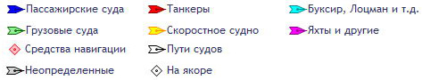
The map shows various types of vessels schematically in different colors (transport, tankers, passenger, high-speed, special, fishing, etc.)

By hovering the cursor over the vessel you need, you can get information about its name and destination. More detailed information is available only after paying the appropriate fee for using the site (annual subscription, subscription depending on the number of vessels you have chosen, and so on).
Service control panel in Russian
The control panel of the Marine Traffic service is divided into two main parts - the left panel and the top panel.
The left pane contains the following options:

The top panel has the following options:
Conclusion
With all the richness of the capabilities of the Marina Traffic website, its free functionality is rather limited, being of interest only in terms of familiarization with the capabilities of the service. The entire completeness of information on the vessel traffic map necessary for the user can be obtained only by paying for the paid functionality of the site, which is really quite impressive, and is fully useful to people associated with the sea and sea transportation.
Maritime site Russia no October 15, 2016 Created: October 15, 2016 Updated: July 25, 2017 Hits: 86819Based on data from AIS. All positions of ships, departure from the port and arrival at the port of destination in real time. Attention! Sometimes the positions of the ships may not correspond to the real ones and lag behind by an hour or more. All coordinates of the positions of the vessels are presented for informational purposes only.

Search data from AIS (AIS) cannot be used to plot a route. When searching, you will find accurate information about the movement of vessels on the map according to AIS data and you can see their photos. In order to find a ship, select a sector on the map, where the number of ships currently located there is indicated.
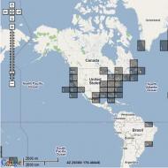
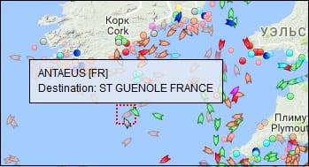
We click with the mouse, for example, on the region of Europe and we get the picture that you see below. If you zoom in on the area, you will see specific ships. The map receives updates every few seconds.
When you hover the cursor over the steamer, you can see its name, on the site you can get other information you are interested in for searching. To find the steamer you are interested in, you should enter the name of the vessel and, if possible, its localization in the search bar and press the search key. Ais map will show the position of the vessel in real time.
What is AIS?
 To reduce the risk of collisions between ships, in 2000, the AIS - Automatic Identification System was developed, that is, the Automatic Identification System. Its functionality turned out to be so successful that after just two years the International Maritime Organization demanded the mandatory installation of AIS terminals on all cargo ships with a displacement of more than 500 register tons, on "trucks" over 300 tons making international voyages, and on all ships for passenger transportation, regardless of tonnage.
Unlike radars, which can detect the appearance of large floating objects near the vessel and approximately estimate their current direction and speed of movement, AIS allows you to get much more detailed and accurate information about the navigation situation.
To better understand the capabilities of the new system, let's first figure out how it works.
The ship's AIS module is a digital VHF transceiver associated with ship's navigation systems. Depending on the speed of the vessel, every 2-10 seconds (every 3 minutes while at a standstill) it automatically transmits the following operational information: MMSI identification number, navigation status ("at anchor", "in motion on the move", etc.). ), current coordinates, true course and speed, yaw rate, and time stamp.
![]() In addition to dynamic data, static data are transmitted every 6 minutes: IMO vessel identification number, its type, name, radio call sign, dimensions, type of positioning system (GPS, GLONASS, LORAN) and even the position of its antenna relative to the bow of the vessel. Route information is transmitted with the same frequency: destination with estimated time of arrival, draft, cargo category and number of people on board. In addition, in the event of a threat to the safety of the vessel, it is allowed to send text messages entered in manual mode.
In addition to dynamic data, static data are transmitted every 6 minutes: IMO vessel identification number, its type, name, radio call sign, dimensions, type of positioning system (GPS, GLONASS, LORAN) and even the position of its antenna relative to the bow of the vessel. Route information is transmitted with the same frequency: destination with estimated time of arrival, draft, cargo category and number of people on board. In addition, in the event of a threat to the safety of the vessel, it is allowed to send text messages entered in manual mode.
The received information can be displayed on the terminal in the form of a table with information about nearby ships, as well as in the form of their symbols superimposed on navigational charts (for example, in a chartplotter) - of course, in this case it is much easier to assess the relative position and dynamics of movement.
![]() In short, according to AIS reports, the captain can absolutely accurately assess the current navigation situation. By the way, radio traffic in the system is carried out in the 162 MHz range, that is, at a much lower frequency than the radiation of radars. Longer radio waves are capable of bending around obstacles such as large ships and small islands, and therefore the range of AIS is pleasantly impressive. It can exceed 40 miles under favorable conditions, but keep in mind that antenna height is critical here, as with other airborne transmitters.
In short, according to AIS reports, the captain can absolutely accurately assess the current navigation situation. By the way, radio traffic in the system is carried out in the 162 MHz range, that is, at a much lower frequency than the radiation of radars. Longer radio waves are capable of bending around obstacles such as large ships and small islands, and therefore the range of AIS is pleasantly impressive. It can exceed 40 miles under favorable conditions, but keep in mind that antenna height is critical here, as with other airborne transmitters.
For yachtsmen, at least those whose ships do not appear in the Forbes magazine charts, the subtlety of using the system is that only simplified version terminals designated "Class B" are allowed to be installed on ships with a displacement of less than 300 tons.
![]() They are distinguished by a markedly reduced transmitter power (2 W versus 12.5 W), which limits the range of their messages to about five miles. Another nuisance is a simplified data transfer algorithm that allows you to send information only if there is free space on the air during the radio exchange of older brothers equipped with class A terminals. The trick is that at any moment in time on any of the two AIS channels transmission of one single block of digital data is possible, and class A devices are able to agree on the order of their issuance in advance.
They are distinguished by a markedly reduced transmitter power (2 W versus 12.5 W), which limits the range of their messages to about five miles. Another nuisance is a simplified data transfer algorithm that allows you to send information only if there is free space on the air during the radio exchange of older brothers equipped with class A terminals. The trick is that at any moment in time on any of the two AIS channels transmission of one single block of digital data is possible, and class A devices are able to agree on the order of their issuance in advance.
However, you must agree: despite such discrimination, being in a choppy night sea, it is very pleasant to know that on a supertanker passing nearby, the watchman for sure knows about the presence of your 45-foot yacht at his side.
 There is another way to use AIS, and it consists in installing a receiver that does not allow sending any data at all, but is capable of tracking the movements of all ships equipped with full-fledged terminals. By and large, even a separate device is not required for this, since manufacturers like Icom and Standard Horizon have begun to equip top models of VHF-mounted radios with this function.
It is convenient, compact, not expensive, but there is one big "but" - it is difficult to place even a text table on a small screen with a low resolution, let alone build even the most primitive semblance of a map ...
That is why AIS receivers have been developed that do not show graphical information at all, but are able to convert data into packets of the standard NMEA protocol, understood by the vast majority of chartplotters. Plus, some of them can connect to computers via USB, or even transfer data via Wi-Fi to mobile gadgets running Android or iOS. Similar devices are produced, for example, by Weather Dock.
 By the way, when installing AIS equipment, even an additional antenna is not absolutely necessary because it works in the same frequency range with the on-board radio. However, keep in mind that splitters used to connect two different devices to the antenna tend to slightly reduce the signal level, and in case of problems with a single antenna, you will lose two security systems at once.
It would be naive to believe that such an advanced information exchange system was created solely to assist the helmsmen in operational maneuvering. AIS is also responsible for the global monitoring of vessel movements for the benefit of a variety of shipping companies, traffic control centers, and government agencies that may need information about the location of certain vessels or cargo. For this reason, AIS equipment can be based not only on ships, but also on coastal stations, many of which are connected in a global network.
 Well, in order to more effectively use the system for the search and rescue of sailors in emergency situations, emergency buoys are produced that are capable of transmitting AIS information with high priority. There are also so-called virtual buoys - this is the only type of device in the system, whose real location may not coincide with the coordinates in their messages. As a rule, these are transmitters installed on the coast, warning passing ships of hazards such as poorly visible rocks or beaconless headlands that protrude far into the sea.
I must say that AIS receivers are placed even on satellites. After all, it is only on the surface of the Earth that the radius of propagation of its signal is limited by visibility to the horizon, and in space it can be received without problems even from hundreds of kilometers. Today, more than a dozen spacecraft revolve around the planet, monitoring marine traffic.
 It is especially pleasant that you can get to the data on the global movement of ships without being the owner of a shipping company or an agent of the secret service. Information is available on a paid basis (for example, in the full version of Google Earth), however, in a somewhat truncated form, it can also be viewed free of charge, for example, on the resource www.marinetraffic.com, whose interactive maps and user-friendly interface have been replicated on many other nautical sites.
We present to you a unique map with which you can find the location of any ship in the world's oceans, as well as determine the direction of its movement.
The technology behind the card relies on a network of satellites capable of receiving encrypted Automatic Identification System (AIS) signals. This system is designed specifically for civilian navigation and is an encrypted signal transmitted by the ship into orbit. The signal contains basic information not only about the direction of movement of the vessel, but also key data about it - name, type, speed, cargo, port of destination, etc. The information received by the satellites is transmitted to the ground, where it is automatically processed.
The result of this processing is embodied in an interactive map of the movement of ships, which can be seen below.
Interactive ship traffic map
Search for a ship by its name
A legend is attached to the map, thanks to which it is possible to determine the type of ship being monitored. Similar data can be obtained by clicking on its icon on the map. It is possible to observe the movement of ships both in satellite mode and in the mode of overlaying a real picture. In addition, knowing the name of the ship, you can find it on the map. To do this, you must enter the name in the appropriate field in English. If everything is done correctly, the map will center itself on the selected ship.
Video instruction for finding ships on the map
Map update
Almost all the data shown on the map is updated in real time. At the same time, it is worth remembering that the speed of movement of the ship in the open sea is relatively low, so if it seems that the ship is not moving, then perhaps you should just wait. However, the reason for the "freezing" of the ship may be not only this - the AIS satellite network still has "white spots" in the world's oceans, into which ships periodically fall. In this case, you just need to wait until the ship can again communicate with satellites - its location will be updated.
In the near future, we should expect an improvement in this system - the leading maritime powers are constantly improving it in order to constantly monitor the location of ships.
Ship movement map in real time is an interactive map on which you can in the mode online observe the movement of ships. Also, by clicking on the map, you can find out information about a specific vessel. The map is currently tuned to the region of Italy. But the map can be dragged with the mouse right in the interactive window. If you want to see more ships, drag the map with the mouse to another area. Ships can be sorted using the menu in the upper right corner of the map map options. Also, you can reduce the scale of the map:
In honor of the Day of the Black Sea Fleet, I have prepared a short review related to the naval theme.
Quick reference:
Day of the Black Sea Fleet is an annual holiday celebrated on May 13 in honor of the creation of the Black Sea Fleet. The day was established in 1996.
After the annexation of Crimea to Russia, Empress Catherine II signed a decree establishing the Black Sea Fleet. On May 13, 1783, 11 ships of the Azov flotilla under the command of Admiral Fedot Klokachev entered the Akhtiar Bay of the Black Sea. This happened two months after the annexation of Crimea to Russia.
Soon the construction of a city and a port began on the shores of the bay, which became the main base of the Russian fleet and was named Sevastopol.
Since the theme is nautical, the map is corresponding - "Map of the movement of ships in real time", presented by the MarineTraffic.com portal: 
Initially, the map is divided into squares, when you zoom in, multi-colored ships appear, which determine the location of specific ships. You can click on any vessel, the corresponding information, photo, route sheet, etc. will appear. Information about ships can reach within an hour, so the data comes in almost real time. At the moment, the database contains more than 10,000 ships, each of them can be found in the gallery of the site. 

Also on the site you can look at photos of ports from anywhere in the world, separately collected places where there is a broadcast of panoramic views through webcams, and a lot of interesting information on marine topics.
And once again I congratulate everyone on the Day of the Black Sea Fleet!
On this page you can watch the movement of sea and river vessels in real time.
AIS (Automatic Identification System, (English AIS Automatic Identification System) - in navigation, a system serving to identify ships, their dimensions, course and other data using VHF / VHF radio waves.
Recently, there has been a tendency to treat AIS as an Automatic Information System (AIS Automatic Information System), which is associated with the expansion of the system's functionality in comparison with the ordinary task of identifying ships.
In accordance with the SOLAS 74/88 Convention, it is mandatory for ships with a displacement of over 300 gross tons on international voyages, ships with a displacement of more than 500 gross tons that do not make international voyages and all passenger ships. Ships and yachts with a smaller displacement can be equipped with a class B device. Data transmission is carried out on the international communication channels AIS 1 and AIS 2 in the SOTDMA protocol (Eng. Self Organizing Time Division Multiple Accsess). Frequency modulation with GMSK keying is applied.
Appointment
AIS is designed to increase the level of safety of navigation, the efficiency of navigation and operation of the vessel traffic control center (VTSC), environmental protection, ensuring the performance of the following functions:
As a means of collision avoidance in ship-to-ship mode;
as a means of obtaining information about the vessel and cargo by the competent coastal services;
as a vessel-to-shore VTSC tool for vessel traffic management;
as a monitoring and tracking tool for ships, and in search and rescue (SAR) operations.
AIS components
AIS system includes the following components:
VHF transmitter,
one - two VHF receivers,
receiver of global satellite navigation (for example, GPS, GLONASS), for Russia the GLONASS module in the AIS device is strictly mandatory, the main source of coordinates. GPS - auxiliary and can be taken from the GPS receiver via the NMEA bus;
modulator / demodulator (converter of analog data to digital and vice versa),
microprocessor controller
equipment for input-output of information to control elements
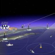
The principle of the AIS
System Overview from US Coast Guard
The AIS operation is based on the reception and transmission of messages over VHF waves. The AIS transmitter operates at longer wavelengths than radars, which makes it possible to exchange information not only at direct distances, but also in terrain that has obstacles in the form of not very large objects, as well as in bad weather conditions. Although one radio channel is sufficient, some AIS systems transmit and receive over two radio channels in order to avoid interference problems and not disrupt the communication of other objects. AIS messages may contain:
Identification information about the object,
information about the state of the object, obtained automatically from the control elements of the object (including from some electro-radio navigation devices),
information about the geographic and time coordinates that the AIS receives from the global navigation satellite system,
information entered manually by facility maintenance personnel (safety related).
The transfer of additional text information between AIS terminals (paging) is provided. The transmission of such information is possible both to the address of all terminals within the range, and to one specific terminal.
In order to ensure the unification and standardization of AIS in the International Radio Regulations, two channels are assigned for use for AIS purposes: AIS-1 (87В - 161.975 MHz) and AIS-2 (88В - 162.025 MHz), which should be used everywhere, with the exception of regions with special frequency regulation.
The digital information transmission rate in the AIS channel is 9600 bit / s.
The operation of each AIS station (mobile or base) is rigidly synchronized in UTC time with an error of no more than 10 μs from the built-in GNSS receiver (in the Russian Federation according to the signals of the combined GNSS GLONASS / GPS receiver). To transmit information, continuously repeating frames with a duration of 1 minute are used, which are divided into 2250 slots (time intervals) with a duration of 26.67 ms.
The text uses 6-bit ASCII codes.
The display of information about the environment in modern AIS is possible in 2 modes - both textual in the form of a table with a list of nearby vessels and their data, and in the form of a simplified schematic map, with an image of the relative position of vessels and distances to them (calculated automatically from the transmitted by them geographic coordinates.) AIS is included in the list of equipment provided with uninterruptible power supply from batteries without fail.
Message structure
Static information
MMSI number
International Maritime Organization (IMO) Number
Radio call sign and name of the floating craft
Dimensions (edit)
Floating device type
Antenna location data (from GNSS Glonass or GPS)
Data is transferred every 6 minutes
Dynamic information
Location (latitude and longitude)
Time (UTC)
Age of information (how long ago it was updated)
True course (relative to the ground), heading angle
True speed
Roll angle, trim
Pitching angle
Angular rate of rotation
Navigation status (for example: Can't steer or Limited in ability to maneuver)
And other information from repeaters and sensors of electro-radio navigation devices and systems
Other information
Destination
Arrival time (ETA)
Draft of the vessel
Cargo information (class \ cargo category)
Number of people on board
Messages for warning and ensuring the safety of cargo transportation
The throughput of each channel is up to 2000 messages per minute.
Source wikipedia
MarineTraffic
This open, community-based project is designed to collect and present data that can be used in research, such as:
- Study of maritime telecommunications in relation to efficiency and propagation parameters
- Simulation of vessel movements to assist in the field of safety of navigation and to resolve critical situations
- Interactive design information systems
- Design of databases providing information in real time
- Statistical processing of port traffic using applications in operational research
- Development of applications for identifying pollution sources
- Development of efficient algorithms for the sea route and evaluation to determine the estimated time of arrival of the vessel
- Correlation of received information with meteorological data
- Collaboration with Institutes dealing with environmental protection.
This project provides free real-time information to the public about the movement of ships mainly along the coastline in many countries of the world.
The project is currently organized by the Department of Product and Systems Engineering Design, Aegean University, Greece.
The collection of primary data is based on the Automatic Identification System (AIS).
There is a constant search for partners to work in the community.
They will have an AIS receiver installed and will be able to share data from their area with others to cover as many destinations and ports around the world as possible.
The system is based on AIS (Automatic Identification System). Since December 2004, the International Maritime Organization (IMO) has required that every vessel over 299 GT has an AIS transmitter that transmits coordinates, speed, heading and various static information such as vessel name, dimensions and flight details.
AIS was originally intended to help ships avoid collisions and to assist port authorities to better manage maritime traffic.
An AIS transponder on board a ship includes a GPS (Global Positioning System) receiver and a VHF transmitter that transmits data on the movement of the vessel on two channels (frequencies 161.975 MHz and 162.025 MHz) and makes this data available to the public. Other vessels or base stations can receive this information and use special software to display the vessel's positions on a chartplotter or computer.
Typically, ships with an SAI receiver connected to an external antenna located 15 m above sea level will receive information in the 15-20 nautical miles range. A base station located at a higher altitude can extend the reception range to 40-60 nautical miles, even over mountains, depending on terrain, antenna type, obstructions around the antenna and weather conditions. The most important factor is the antenna height. The higher the better. For example, an antenna located on a mountain at an altitude of 700 m can receive signals from ships at a distance of 200 nautical miles!
Base stations, which confidently cover a range of 40 nautical miles, can periodically receive signals from more distant vessels.
The base station is equipped with a maritime band antenna, AIS receiver and a computer connected to the Internet.
The AIS device receives data, which is processed using simple software on a PC, and then this data is sent to a central database via a web service. The software is free for interested users, under the GNU license.
The data received by the AIS receiver is encoded into a single NMEA sentence (64-bit plain text).
Example:! AIVDM, 1,1, B, 1INS<[email protected],0*38
There are three main types of messages:
1. Dynamic information - vessel position, speed, current position, heading and rate of turn.
2. Static information - ship name, IMO number, MMSI, dimensions.
3. Special information - assignment, ETA and projects.
The central database receives and processes a large amount of data, and stores the most important parts of it. It also includes port and geographic information areas, ship photos and other information. The vessel's current positions and / or tracks are displayed on a map using Google Map API.
The resulting data is loaded into the database in real time and, therefore, is immediately highlighted on the map. However, some positions shown on the map may not be constantly updated (for example, when the ship goes out of range). The ship positions shown on the chart may be out of date up to 1 hour.
MarineTraffic only covers certain coastal areas where AIS ground receiving base stations are installed.
Possible reasons why the positions of ships are not displayed on the map are as follows:
- The vessel is not equipped with an AIS transponder, the transponder does not work or does not work correctly;
- The ship is located in an area where there is no base AIS receiving station nearby;
- The transponder power is not sufficient for normal signal reception by the ground station. The power of class A transponders is much lower than the power of class B transponders.
It also depends on the type and height of the antenna and on the type of cable.
- AIS transponder is incorrectly tuned.
Map icons may appear slowly. This could be due to too many ships being displayed, web technology, javascript and web browsers.
The Internet Explorer browser (especially version 6 and older) is very ineffective in this kind of web application.
The following browsers show significantly better performance and we suggest using one of them: Opera, Chrome, Firefox.
The system can receive the positions of ships that have not yet transmitted static information (name, dimensions, etc.) This is because static ships transmit information more rarely. In this case, instead of the name of the vessel, its MMSI will be displayed (for example, 239923000). There is also a small chance of incorrect or distorted data recording.This happens for the following reasons:
a) malfunction of the ship's AIS transponder
b) Global Positioning System (GPS) error and
c) neglect of the ship's crew to properly tune the information transmitted by the AIS transponder (this refers to static information such as ship name, type and size, as well as destination and estimated time of arrival).
The system is based solely on information received from ships transmitted by their AIS transponder.
Therefore, the correct configuration of the AIS transponder by the crew is very important! In particular, the person in charge of the operation of the AIS transponder can greatly assist in the correct presentation of information about the vessel by taking care of the following:
a) Correct update and verification of the Static Information that is written to the AIS block. These include: name of vessel, type of vessel, size of vessel, IMO, MMSI number, relative position of the AIS device.
b) Correct update of Movement Information, i.e. destination, ETA and draft, prior to the start of each voyage. If this information is correct, the vessel will appear in "Awaiting Arrival" for each port and an estimate of the arrival time will be given for all interested parties. One port must be entered at a time, and any additional information (eg country or multiple ports) should be avoided.
Moving ships are displayed as ship icons. Vessels that are not moving or moving at a speed of less than 0.5 knots, anchored or moored are displayed as squares.
Ship icons and tracks are colored according to their type (cargo, tanker, passenger, etc.)
The MarineTraffic system can be expanded to cover any area around the world. You can independently install an antenna, AIS receiver, connect it to a computer connected to the Internet and start sending data immediately. You will immediately see on the map the vessels that have been accepted by your receiver. For those wishing to cover their area on the map, there is a confirmation on the main site, links to a company or personal site, or any other links upon request.
If you have a private sailboat that is within range covered by MarineTraffic, you can install an AIS transponder on board to record your position on a map in real time. The installation of an AIS transponder on small craft is optional and you are allowed to use a CLASS “B” transponder. CLASS "B" is cheaper than CLASS "A". CLASS "B" transponders are intended for vessels with a displacement of less than 300GT. Price from 700 to 2000 euros.
In addition, you can use the iAIS application on your smartphone (iPhone / iPad or Android) on board to report the position of your vessel directly to MarineTraffic, without the need for an AIS transponder.
There are at least 5 different methods for submitting your own position in MarineTraffic.
Related Articles